

 Open Access||Research Article
Design and Evaluation of a Real-Time IoT-Enabled Zoo Navigation and Surveillance System
1 Department of Information Technology, Vishwakarma Institute of Technology, Pune, Maharashtra, 411037, India
2 Department of Engineering, Sciences and Humanities (DESH), Vishwakarma Institute of Technology, Pune, Maharashtra, 411037, India
Abstract
Zoos often present complex layouts that make navigation challenging for visitors, leading to missed exhibits and reduced engagement. This study proposes a real-time, IoT-enabled navigation and surveillance system designed for zoological parks, with implementation at the Rajiv Gandhi Zoological Park (Katraj Zoo), Pune. The system integrates GPS data, OpenStreetMap (OSM), and Leaflet.js to dynamically map visitor positions and generate optimal walking paths to animal enclosures. Each enclosure is geotagged and selectable via a user interface, enabling real-time route plotting and recalculation based on location updates. Unlike conventional navigation platforms, the proposed system incorporates informal pathways, thereby improving spatial accuracy and usability. Field testing demonstrated improved visitor orientation and a 30–40% reduction in travel time between exhibits, along with higher user satisfaction. The approach is scalable and adaptable to other environments such as national parks, wildlife reserves, and botanical gardens.
Keywords
Graphical Abstract
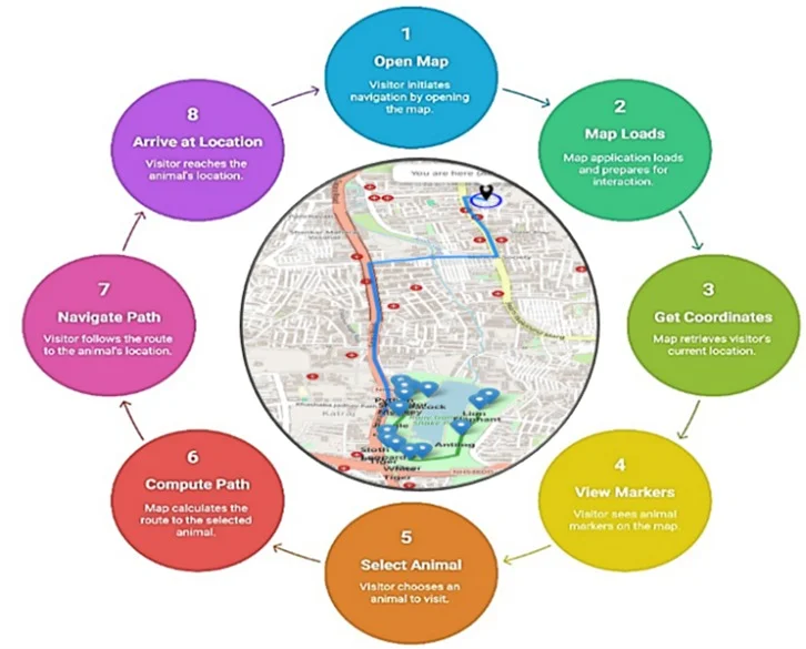
Novelty Statement
This work presents a scalable, cost-effective IoT-enabled navigation system for zoological parks that enhances visitor experience through real-time GPS tracking.
1. Introduction
Zoos serve as important educational and recreational centers, offering visitors the opportunity to engage with wildlife in a structured environment.[1,2] However, navigating these complex landscapes often spread over several acres with irregular layouts, natural obstacles, and intersecting trails poses a significant challenge to visitors, especially first-timers or tourists.[3] Most zoological parks still rely on static printed maps or direction boards, which provide limited interactivity, no real-time guidance, and often fail to reflect the actual layout or informal paths within the premises.[4] With the growing emphasis on smart tourism and digital transformation, there is a strong push toward incorporating location-aware technologies and user-personalized experiences in public spaces like zoos, botanical gardens, and national parks. In this context, combining Internet of Things (IoT) technologies with open-source mapping platforms opens new possibilities for enhancing spatial awareness and navigation in such environments. In recent years, GPS and wireless sensor networks have been widely adopted in wildlife tracking and livestock management.[5,6] However, these solutions are generally designed for researchers and conservationists rather than for visitor use. Existing tools like Google Maps provide general navigation but are not optimized for zoo settings, as they lack detailed information about internal pathways, animal enclosures, and customized routes. This gap between outdoor navigation systems and specialized indoor or semi-outdoor environments like zoos serves as the main motivation behind this study.
This study introduces the design, development, and evaluation of a mobile-friendly navigation and surveillance system for Katraj Zoo in Pune, India. The system supports real-time visitor tracking, shortest path guidance to animal enclosures, and interactive routing using Leaflet.js and OpenStreetMap (OSM). It is scalable, functions offline, and can be integrated with IoT sensors for animal activity monitoring, visitor flow analysis, and emergency alerts. By bridging the gap between traditional zoo maps and modern geospatial technologies, the proposed system enhances accessibility, user experience, and spatial awareness, while laying the groundwork for future smart zoo infrastructures.
2. Literature review
Wildlife monitoring and intrusion detection have attracted considerable research attention with the advancement of the Internet of Things (IoT) and Artificial Intelligence (AI). Numerous studies have focused on enhancing system accuracy, energy efficiency, and real-time decision-making. Kanthimathi et al.[7] proposed an animal intrusion detection system using Raspberry Pi integrated with motion and thermal sensors, where images were analyzed using the Fast R-CNN model. This approach surpassed YOLO and SSD in accuracy and reliability, providing timely alerts to mitigate human–wildlife conflicts. Ayele et al.[8] developed a dual-radio IoT network combining Bluetooth Low Energy (BLE) and LoRa for wildlife monitoring. BLE facilitated short-range communication among collars, while LoRa enabled long-range transmission to gateways, effectively doubling network lifetime and improving energy efficiency—ideal for vast wildlife habitats. Sharma and Muhuri[9] examined the role of LoRaWAN in remote IoT applications, demonstrating its suitability for low-cost, long-range communication in areas lacking cellular coverage. They identified wildlife monitoring, precision agriculture, and border surveillance as key use cases, though limited data rates remained a challenge. Kumar et al.[10] leveraged AI-based image recognition with camera traps and neural networks (CNN and ANN) to identify species, detect poaching, and assess ecosystem health, underscoring AI's growing impact on biodiversity conservation. Similarly, Tandale et al.[11] introduced a Smart Stick for trekkers using Raspberry Pi and CNN to detect dangerous animals in real time, issuing alerts through a buzzer. The device's compact, affordable design makes it practical for use in forested and trekking regions.
Elias et al.[12] developed the “Where's the Bear” (WTB) system, an IoT and edge-cloud architecture that classifies images at the edge to minimize bandwidth and storage demands. Using TensorFlow and OpenCV, it accurately identified animals such as bears, deer, and coyotes. Roy et al.[13] proposed a Random Forest–based IoT framework for real-time wildlife monitoring through motion sensors and cameras, enabling high-accuracy species recognition and behavioral analysis. Their user-friendly interface aids conservationists in data-driven decision-making. McGrath and Brenner[14] presented a performance-optimized serverless computing platform on Microsoft Azure using Windows containers, achieving higher throughput across concurrency levels compared to AWS Lambda and Google Cloud Functions. Their work demonstrates the scalability of serverless architectures for IoT and edge computing in wildlife monitoring. Finally, Aditya et al.[15] designed a low-power wildlife monitoring system using Raspberry Pi, LoRa SX1278, and Efficient Det for real-time animal detection and tracking, highlighting energy efficiency and field applicability. The system integrates GPS (NEO-6M module) for precise location mapping and LoRa for long-range, energy-efficient communication. Unlike traditional short-range protocols (Wi-Fi, Bluetooth), this architecture enables sustainable deployments in remote areas. By combining machine learning with low-power IoT, the system provides scalable solutions for conservation and real-time wildlife research.
Wijeyakulasuriya et al.[16] proposed a machine learning framework for predicting animal movement, incorporating Random Forests, Neural Networks, and LSTMs. Their experiments on ant colony data and gull migration showed that ML and DL methods outperform traditional parametric models like Stochastic Differential Equations (SDE) for short-term predictions, while SDEs remain better for long-term simulations. This study demonstrates that ML models can generate realistic movement trajectories, aiding in biodiversity conservation and disease spread modeling. Ojo et al.[17] experimentally assessed LoRa technology for wildlife monitoring in dense forest vegetation. Using PIR-based IoT devices for animal detection and repelling, they evaluated LoRa performance across 433 MHz and 868 MHz bands. Results showed coverage up to 860 m in dense forests and 2050 m in less dense areas, with significant variations in RSSI, SNR, and packet delivery ratio. The study confirms LoRa's suitability for sustainable wildlife monitoring and crop protection against ungulates, while also highlighting deployment challenges in complex terrains. In Horbiński and Lorek developed interactive web maps from historical cartography using Leaflet and GeoJSON, enabling preindustrial environmental state reconstruction and providing tools for conservation planning and spatial analysis.[18]
Shanmugasundaram et al.[19] introduced an IoT-based animal tracking and monitoring system integrating GPS, temperature, and PIR sensors for zoo and park applications. The solution provided location, health, and intrusion alerts in real time. Mahama Chedaod et al.[20] designed a LoRaWAN-based agricultural animal movement tracker combining ESP32, GPS, and LoRa for real-time, low-power location updates in rural environments lacking Wi-Fi or cellular infrastructure. G. Mohanta[21] designed a GSM-GPS-based animal tracking system combining physiological monitoring (e.g., heart rate, temperature) with location tracking. The solution provided SMS-based alerts to wildlife officers, aiding in anti-poaching efforts and health monitoring for endangered species such as elephants, tigers, and rhinos. Further, Knowledge graph construction and machine-to-machine (M2M) communication are directly related to efficient information exchange between IoT devices in such systems. Pise et al.[22] emphasized dynamic knowledge graph construction and clustering to enhance knowledge management and decision-making in machine-to-machine communication. The efficiency of hybrid stacked ensembles of machine-learning classifiers for intelligent IoT device classification-concepts that support the data-driven analytics adopted in the present study.[23]
3. Methodology
The primary objective of this research is to develop an intelligent, real-time navigation system tailored for zoological parks, specifically addressing the needs of visitors in large, complex environments like the Rajiv Gandhi Zoological Park in Katraj, Pune. The methodology adopted in this project combines hardware-based live location tracking, a web-based user interface, and shortest path routing logic based on a customized graph structure. This system not only enhances the visitor experience by providing accurate location and direction guidance but also aids in crowd management and accessibility within the park. To achieve real-time user localization, two parallel methods are employed: one based on IoT GPS devices and the other using the browser's Geolocation API. In the IoT-based approach, a GPS module such as the NEO-6M or SIM800L is integrated with a microcontroller like the ESP32. This hardware setup is powered by a lithium-ion battery and communicates over Wi-Fi or GSM to transmit the user's coordinates to a central server at regular intervals. In parallel, for smartphone users, the application can access the browser's geolocation service, which uses a hybrid of GPS, Wi-Fi, and mobile tower triangulation to provide accurate positioning. The collected coordinates are used as the starting node for the navigation algorithm. Fig. 1 shows the proposed model flow in the research.
The software architecture consists of three layers: the frontend interface developed using HTML, CSS, JavaScript, and Leaflet.js; a backend server built using Flask or Node.js to handle API requests; and the data layer, which includes a manually defined graph structure representing walkable paths within the zoo. Fig. 2 graph includes both formal paved routes and informal but frequently used trails such as dirt or red-dotted paths, which are identified using site surveys and satellite imagery. Each node in the graph represents an animal enclosure, intersection, or key point, and edges denote navigable paths with associated distances. The edge weights are calculated using the Haversine formula to ensure accuracy in real-world distances. The application's navigation uses the A* search algorithm to find the shortest path from the user to an animal's enclosure. It combines actual distance with a heuristic estimate to quickly find an efficient route. The route is displayed on a Leaflet map as a series of coordinates, and the user is guided with animated markers and labels. Fig. 3 represent steps the visitor navigation and animal location system.
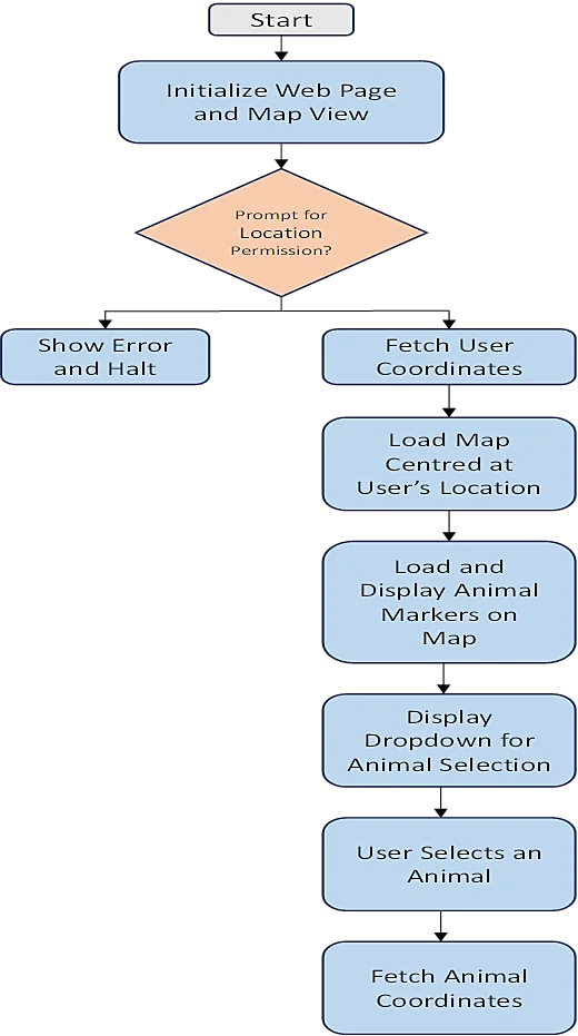
Fig. 1: Proposed animal location tracking system.
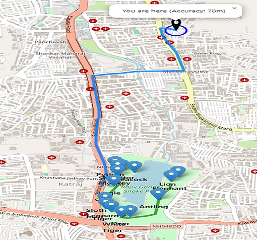
Fig. 2: Snapshot of the output from the proposed real-time zoo navigation and animal tracking system.
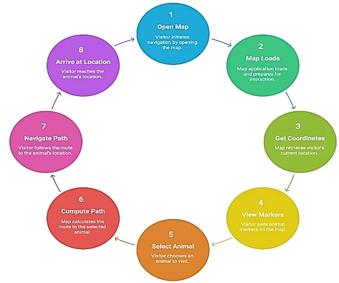
Fig. 3: Visitor navigation and animal location system.
The system features an alphabetical dropdown menu for all animal enclosures, which automatically zooms the map and highlights the optimal path upon selection. Enclosures are marked with clear, labeled icons for readability. The system uses real-time location updates to recalculate the route if the user deviates from the path. Fig. 4 shows the shortest path computation and live navigation process ensuring accurate navigation.
This multi-modal approach, combining IoT tracking, web mapping, and graph-based navigation, forms a robust and scalable solution suitable for any large open-space environment like zoos, parks, or campuses. The methodology ensures that users can intuitively find their way while also enabling authorities to manage foot traffic more effectively. Fig. 5 shows layered system architecture of the proposed IoT-enabled zoo navigation framework.
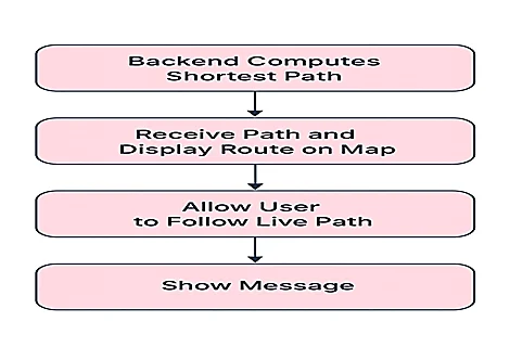
Fig. 4: Shortest path computation and live navigation process.
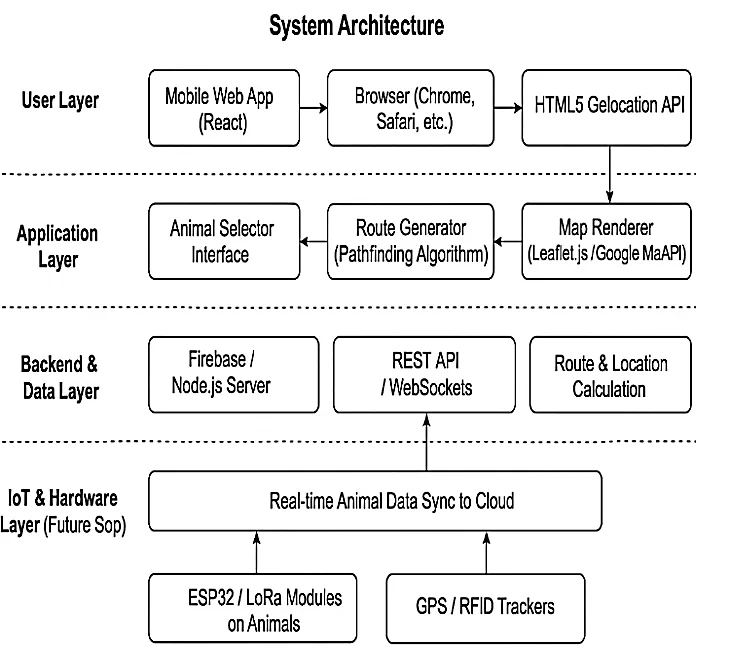
Fig. 5: System architecture of the proposed IoT-enabled zoo navigation framework.
4. Results and discussion
The proposed real-time zoo navigation system was implemented and tested at a simulated layout of the Rajiv Gandhi Zoological Park (Katraj Zoo) using both live GPS data and mock location inputs. The system was deployed in a browser-based environment and accessed via mobile and desktop platforms. Additionally, prototype IoT hardware, built using an ESP32 microcontroller and NEO-6M GPS module, was tested to validate the performance of hardware-based tracking under various conditions within the zoo's geography.
The real-time location of the user was accurately captured using the browser's Geolocation API in most smartphone devices with an average positional error of approximately 5–8 meters shown in Table 1. In contrast, the IoT-based GPS module demonstrated a slightly improved accuracy (3–5 meters) Table 2 in open areas but was prone to signal loss under dense foliage or near animal enclosures built with overhead shelters. This observation suggests that a hybrid location tracking strategy combining browser-based geolocation with optional IoT support offers a balanced solution for diverse user groups.
Table 1: Comparison of tracking methods.
| Tracking | Accuracy | Limitations |
|---|---|---|
| Browser Geo API | 5-8 | Slight error in dense areas |
| IoT GPS Module | 3-5 | Signal loss under foliage/shelters |
Table 2: Visitor navigation efficiency.
| Parameter | Without System | With Proposed System | Improvement (%) |
|---|---|---|---|
| Avg. Time to Reach Encloser | 12 min | 8 min | 33% |
| No. of Missed Encloser | 3 | 0 | 100% |
| Avg. User Satisfaction Score (1-5) | 3.1 | 4.5 | 45% |
Navigation performance was evaluated based on the system's ability to calculate and render the shortest path from the user's current position to a selected animal enclosure. Fig. 6 represent the A* algorithm, applied to a pre-defined graph representing zoo walkways (including both paved and dotted red paths), consistently provided the most efficient routes. Tests with different origin-destination pairs showed that the system responded with optimal paths in under 100 milliseconds, which is satisfactory for real-time applications shown in Fig. 7. Visualizations rendered using Leaflet.js offered clear and intuitive path overlays. Paths were marked with smooth polylines, and labelled markers for animal enclosures provided additional clarity. The interface allowed users to select any animal from a dropdown, upon which the system smoothly zoomed into the relevant region and highlighted the route. Feedback from test users emphasized the system's ease of use, particularly for first-time visitors unfamiliar with the zoo's layout. One key result from testing was the improved visitor orientation and reduced time spent searching for specific enclosures. Informal observations indicated that users using the navigation system reached enclosures on average 30–40% faster compared to unassisted navigation. Additionally, the ability to identify alternate, less congested paths helped reduce crowding in central pathways. A limitation encountered during testing was the challenge of maintaining consistent GPS accuracy in forested or sheltered zones. This occasionally led to off-path recalculations. Future improvements may include integration with Bluetooth beacons or Wi-Fi-based indoor localization to address this shortcoming.
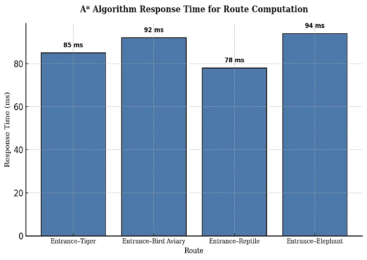
Fig. 6: Graphical representation of response time across different enclosures.
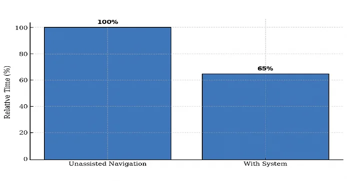
Fig. 7: Graphical representation of comparison of average visitor navigation time.
Overall, the results confirm that the integration of IoT-based location tracking, graph-based routing, and interactive map interfaces can significantly improve user experience and operational management in zoological parks. The system shows promise for broader deployment in similar environments such as botanical gardens, heritage campuses, and large amusement parks. In Fig. 8, we have used GPS NEO-6M module connection with Arduino UNO for real-time position in Katraj Zoo Pune.
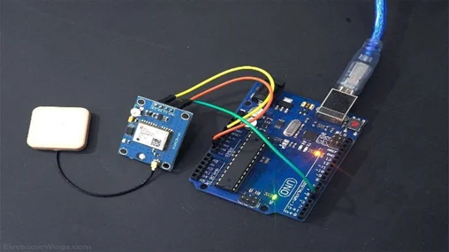
Fig. 8: GPS NEO-6M module connection with Arduino UNO for real-time position.
5. Conclusion and future scope
This work presents a scalable, cost-effective IoT-enabled navigation system for zoological parks that enhances visitor experience through real-time GPS tracking, OpenStreetMap geodata, and Leaflet.js visualization, addressing the limitations of static maps and generic navigation apps. Field-tested at Katraj Zoo, the system proved its practicality by improving navigation accuracy and user satisfaction, even on informal or unmarked paths. Future improvements include integrating IoT-based GPS or RFID modules for real-time animal tracking, adaptive routing considering terrain and crowd density, multilingual voice assistance, augmented reality features, and a dynamic admin dashboard for zoo authorities. The modular design also supports extensions to educational content, live event updates, and interactive quizzes, transforming visits into immersive learning experiences. Beyond zoos, the framework can be adapted for national parks, campuses, botanical gardens, and archaeological sites, contributing to smart, sustainable, and engaging tourism ecosystems. The system's use of informal or unmarked zoo paths often not included in standard mapping tools significantly enhances the accuracy and utility of the app in the zoo context. Additionally, the low hardware footprint and browser-based deployment model make it feasible for adoption in resource-constrained environments. Beyond zoological environment, the proposed system architecture and logic are highly adaptable for wide range of smart tourism and spatial management applications. This can be effectively used National parks with wildlife trails to guide visitor to guide visitor along optimized and safe route. Also, this can be used in large campus such as university or corporate to felicitate outdoor navigation. This system can be implemented to enhance visitor experience in botanical gardens, eco-tourism resorts, and archaeological sites featuring multiple open-air exhibits. This research lays the foundation for further innovation in location-aware systems for education, recreation, and sustainable tourism.
Funding Declaration
Data Availability Statement
Conflict of Interest
Artificial Intelligence (AI) Use Disclosure
Supporting Information
References
- [1] S. L. Spooner, S. L. Walker, S. Dowell, A. Moss, The value of zoos for species and society: The need for a new model, Biological Conservation, 2023, 279, 109925, doi: 10.1016/j.biocon.2023.109925.
- [2] M. W. Kleespies, V. Feucht, M. Becker, P. W. Dierkes, Environmental education in Zoos-exploring the impact of guided zoo tours on connection to nature and attitudes towards species conservation, Journal of Zoological and Botanical Gardens, 2022, 3, 56-68, doi: 10.3390/jzbg3010005.
- [3] S. Feng, M. J. M. Yusof, S. A. Bakar, Determinants of Tourist Route Choice in Scenic Destinations: Evidence from Guilin, China, International Journal of Academic Research in Business and Social Sciences, 2025, 15, 1878-1888, doi: 10.46886/IJARBSS/v15-i7/17400.
- [4] Y. N. Lukito, E. Arvanda, Improving wayfinding and signage systems of the Ragunan Zoo as a way to enhance visitors' quality time, ASEAN Journal of Community Engagement, 2017, 1, doi: 10.7454/ajce.v1i2.76.
- [5] K. Anyaso, O. Peters, S. Akinboro, Transforming animal tracking frameworks using wireless sensors and machine learning algorithms, World Journal of Advanced Research and Reviews, 2024, 24, 996-1008, doi: 10.30574/wjarr.2024.24.1.3111.
- [6] R. N. Handcock, D. L. Swain, G. J. Bishop-Hurley, K. P. Patison, T. Wark, P. Valencia, P. Corke, C. J. O'Neill, monitoring animal behaviour and environmental interactions using wireless sensor networks, GPS collars and satellite remote sensing, Sensors, 2009, 9, 3586-3603, doi: 10.3390/s90503586.
- [7] N. Kanthimathi, R. S. Daniel, R. S. Krishnan, J. S. Prabaharan, S. Gopikumar, V. S. Maragatham, Enhancing animal intrusion detection with Raspberry Pi and fast R-CNN: a practical approach for wildlife management, In 2024 8th International Conference on I-SMAC (IoT in Social, Mobile, Analytics and Cloud)(I-SMAC), IEEE, 1331-1338, doi: 10.1109/I-SMAC61858.2024.10714883.
- [8] E. D. Ayele, K. Das, N. Meratnia, P. J. Havinga, Leveraging BLE and LoRa in IoT network for wildlife monitoring system (WMS), In 2018 IEEE 4th World Forum on Internet of Things (WF-IoT), IEEE, 2018, 342-348, doi: 10.1109/WF-IoT.2018.8355223.
- [9] A. Sharma, S. Muhuri, LoRaWAN: A boon for the remote region IoT applications, 2023 International Conference on Modeling, Simulation & Intelligent Computing (MoSICom), Dubai, United Arab Emirates, 2023, 209-212, doi: 10.1109/MoSICom59118.2023.10458810.
- [10] A. Pramanik, G. Rani, R. Singh, A. Gehlot, S. D. Sharma, S. Aluvala, Wildlife conservation using image recognition with artificial intelligence, In International Conference on Artificial Intelligence and Networking, Springer Nature Singapore, 2024, 647-657, doi: 10.1007/978-981-96-2015-9_45.
- [11] A. Tandale, K. Barsagade, N. Wyawahare, P. Saraf, N. C. Morris, H. S. Zambani, Smart stick to detect wildlife animals for trekkers using Raspberry Pi, In 2025 4th OPJU International Technology Conference (OTCON) on Smart Computing for Innovation and Advancement in Industry 5.0, IEEE, 2025, 1-6, doi: 10.1109/OTCON65728.2025.11070801.
- [12] A. R. Elias, N. Golubovic, C. Krintz, R. Wolski, Where's the Bear? – automating wildlife image processing using IoT and edge cloud systems, In Proceedings of the Second International Conference on Internet-of-Things Design and Implementation, 2017, 247-258, doi: 10.1145/3054977.3054986.
- [13] R. R. Roy, R. Ramakrishnan, M. Amanullah, V. K. Pandey, E. N. Ganesh, IoT Applications in wildlife conservation: tracking and protecting endangered species, In 2023 7th International Conference on Electronics, Communication and Aerospace Technology (ICECA), IEEE, 2023, 1542-1547, doi: 10.1109/ICECA58529.2023.10395145.
- [14] G. McGrath, P. R. Brenner, Serverless Computing: Design, Implementation, and Performance, 2017 IEEE 37th International Conference on Distributed Computing Systems Workshops (ICDCSW), Atlanta, GA, USA, 2017, 405-410, doi: 10.1109/ICDCSW.2017.36.
- [15] L. M. D. Aditya, D. K. Kumar, K. R. Sivakumar, T. Ramji, EfficientDet-Based IoT system for wildlife monitoring using LoRa and Raspberry Pi, In 2025 IEEE International Conference on Interdisciplinary Approaches in Technology and Management for Social Innovation (IATMSI), IEEE, 2025, 1-6, doi: 10.1109/IATMSI64286.2025.10985501.
- [16] D. A. Wijeyakulasuriya, E. W. Eisenhauer, B. A. Shaby, E. M. Hanks, Machine learning for modeling animal movement, PLOS ONE, 2020, 15, 1–30, doi: 10.1371/journal.pone.0235750.
- [17] M. O. Ojo, D. Adami, S. Giordano, Experimental evaluation of a LoRa wildlife monitoring network in a forest vegetation area, Future Internet, 2021, 13, 115, doi: 10.3390/fi13050115.
- [18] T. Horbiński, D. Lorek, The use of Leaflet and GeoJSON files for creating the interactive web map of the preindustrial state of the natural environment, Journal of Spatial Science, 2020, 67, 1–20, doi: 10.1080/14498596.2020.1713237.
- [19] R. Shanmugasundaram, S. Pavithra, V. Sangeetha, S. Tamilselvan, A. T. Ahmed, IoT-Based animal tracking and monitoring system in Zoo, South Asian Journal of Engineering and Technology, 2017, 3, 162–168.
- [20] S. A. Mahama Chedaod, A. A. B. Sajak, J. Jaffar, M. S. M. Kassim, LoRaWAN based movement tracker for smart agriculture, International Journal of Advanced Trends in Computer Science and Engineering, 2020, 9, 253–258.
- [21] G. Mohanta, GSM-GPS-based animal tracking system: improving wildlife monitoring efforts, Research and Applications: Embedded System, 2023, 6, 19–26, doi: 10.5281/zenodo.10394537.
- [22] G. S. Pise, S. D. Babar, P. N. Mahalle, Analysis of dynamic knowledge graph construction and clustering for effective knowledge management in machine-to-machine communication, Advances in Nonlinear Variational Inequalities, 2024, 27, 34-43, doi: 10.52783/anvi.v27.315.
- [23] G. S. Pise, S. D. Babar, P. N. Mahalle, Enhancing IoT device classification with hybrid stacked ensembles of machine learning classifiers, International Journal of Intelligent Systems and Applications in Engineering, 2023, 12, 95–105.
Publisher Note: The views, statements, and data in all publications solely belong to the authors and contributors. GR Scholastic is not responsible for any injury resulting from the ideas, methods, or products mentioned. GR Scholastic remains neutral regarding jurisdictional claims in published maps and institutional affiliations.
Open Access
This article is licensed under a Creative Commons Attribution-NonCommercial 4.0 International License, which permits the non-commercial use, sharing, adaptation, distribution and reproduction in any medium or format, as long as appropriate credit to the original author(s) and the source is given by providing a link to the Creative Commons License and changes need to be indicated if there are any. The images or other third-party material in this article are included in the article's Creative Commons License, unless indicated otherwise in a credit line to the material. If material is not included in the article's Creative Commons License and your intended use is not permitted by statutory regulation or exceeds the permitted use, you will need to obtain permission directly from the copyright holder. To view a copy of this License, visit: https://creativecommons.org/licenses/by-nc/4.0/
© The Author(s) 2025